Boulder, Colorado is located at the base of the Rocky Mountains and experiences various natural hazards that can lead to disasters. Some quick answers regarding natural disasters in Boulder are:
- Yes, Boulder is vulnerable to wildfires, floods, severe storms, and geological hazards like landslides.
- Wildfires are a major threat during dry seasons, with large fires occurring near Boulder in 2010 and 2022.
- Flash flooding is also a risk, especially along Boulder Creek, after heavy rains over burn scars.
- Tornadoes have struck Boulder County in the past, though they are rare.
- Landslides and rockfalls occur in the nearby foothills and mountains.
Wildfire Risk
Wildfires are one of the most significant natural hazards facing Boulder, Colorado and the surrounding areas. The foothills and mountains near Boulder contain dense forests and vegetation that can fuel large, dangerous wildfires under dry conditions. Wildfires are likely during hot, dry late spring and summer months as well as drought periods.
Several major wildfires have impacted Boulder County in recent years. In 2010, the Fourmile Canyon Fire burned over 6,000 acres and destroyed nearly 170 homes and structures west of Boulder. More recently, the 2022 Marshall Fire destroyed over 1,000 structures and burned over 6,000 acres in Boulder County. Smaller wildfires frequently threaten the area as well.
The wildland-urban interface areas near Boulder are particularly at risk. Development has expanded into forested areas, increasing wildfire vulnerability. Embers can easily blow into neighborhoods from nearby burns. The abundant open space and mountain parks surrounding Boulder also provide fuel for wildfires.
Various factors contribute to increasing wildfire risk near Boulder:
- Hot, dry conditions and drought that dry out vegetation
- High winds to spread fires
- Presence of conifer trees and other flammable vegetation
- Increasing development in forested areas
- Past fire suppression that increased fuel loads
- Climate change exacerbating hot, dry conditions
To mitigate wildfire risk, land management agencies conduct vegetation thinning and prescribed burns near Boulder. Property owners are encouraged to create defensible space and use fire-resistant building materials and landscaping. When wildfires occur, firefighters work to suppress the blazes and aircraft drop fire retardant. Evacuation of threatened neighborhoods is a key response.
Major Wildfires Near Boulder, Colorado
| Fire Name | Year | Acres Burned | Structures Destroyed |
|---|---|---|---|
| Marshall Fire | 2022 | 6,026 | 1,084 |
| Fourmile Canyon Fire | 2010 | 6,181 | 169 |
| Overland Fire | 2003 | 3,500 | 0 |
| Black Tiger Fire | 1989 | 1,778 | 44 |
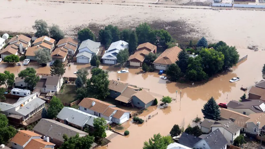
Flood Risk
Flooding is another major natural hazard for Boulder, Colorado. The area is vulnerable to flash flooding, river flooding, and post-fire flooding.
Boulder Creek runs along the south side of downtown Boulder. The creek drains a watershed of nearly 400 square miles encompassing steep mountain canyons. Heavy rainfall over the watershed can cause rapid rises along the creek through the city. Downtown Boulder suffered damaging floods along Boulder Creek in 1894, 1938, 1969 and 2013.
Smaller mountain streams descending from the foothills into Boulder also frequently overflow and cause flash flooding during intense rainfall. These include Fourmile Canyon Creek, Gregory Canyon Creek, Wonderland Creek, and Skunk Creek among others. Flash floods along these creeks have caused road closures, property damage, and erosion.
In addition, wildfires increase flood risk by burning away vegetation and creating hydrophobic soils that do not absorb water well. Denuded and burned areas see more rapid runoff during rain events that can inundate nearby communities. After the Fourmile Fire, a rainstorm in 2011 caused significant debris flows and flooding in Fourmile Canyon.
To reduce flood impacts, Boulder has enacted floodplain development regulations, constructed flood control dams and levees, employed flood warning systems, and undertaken stream restoration projects. However, substantial flooding remains a threat.
Major Flood Events in Boulder, Colorado
| Year | Flood Type | Impacts |
|---|---|---|
| 1894 | Boulder Creek | Severely damaged downtown Boulder |
| 1938 | Boulder Creek | Inundated much of downtown, killed 5 |
| 1969 | Boulder Creek | Flooded basements downtown |
| 2013 | Boulder Creek & tributaries | Widespread damage downtown and along creeks |
| 2011 | Fourmile Canyon Creek | Debris flows after Fourmile Fire |
Tornado Risk
Tornadoes are a more minor but still notable natural hazard for the Boulder area. While tornadoes occur much less frequently compared to the Great Plains, tornado development is possible with severe thunderstorms on Colorado’s eastern plains.
Most tornadoes near Boulder are relatively weak EF0 or EF1 storms. However, stronger tornadoes have impacted the region. In 2008, an EF3 tornado touched down northwest of Boulder and remained on the ground for nearly 40 miles, causing damage near the towns of Windsor and Platteville.
Historically, a violent F4 tornado struck Boulder in 1967. This large tornado carved a 10-mile path from south of Boulder to north of the city, injuring 19 people. An F3 tornado also went through Lafayette just east of Boulder in 1990.
Typical tornado conditions include a cold front colliding with warm humid air, causing supercell thunderstorms. Tornado chances are highest in May and June as warm unstable air masses move northward. Most tornadoes occur in late afternoon and early evening hours.
Due to the more limited tornado risk, few mitigation measures exist besides tornado warnings during severe weather and emergency plans for taking shelter when a warning is issued.
Major Tornadoes Striking Boulder, Colorado
| Date | Strength | Path Length | Injuries/Deaths |
|---|---|---|---|
| June 15, 1967 | F4 | 10 miles | 19 injuries |
| July 11, 1990 | F3 | 6 miles | 0/1 |
| May 22, 2008 | EF3 | 39 miles | 1 injury |
Landslide & Rockfall Risk
Due to the proximity to steep foothills and mountains, landslides and rockfalls represent another natural hazard around Boulder. Intense rainfall events or snowmelt can destabilize slopes and trigger debris flows and slides.
Some recent examples include:
- In 2019, heavy rains triggered a damaging landslide that closed State Highway 72 in Coal Creek Canyon west of Boulder for several days.
- In 2013, three days of heavy rains caused a large sinkhole from a deep landslide near the homestead cabins on Flagstaff Mountain.
- Numerous small rockfalls from eroding sandstone cliffs have caused road closures in Boulder Canyon along State Highway 119.
Development along the base of slopes below mesas and in mountain canyons has increased landslide risks. Over-steepened cut slopes and excessive groundwater infiltration from leaking pipes are other contributing factors. Mitigation involves stabilizing slopes, regulating canyon development, and early warning systems.
While not as frequent as wildfires and floods, destructive landslides have the potential to occur on unstable slopes near Boulder, especially during extreme precipitation or snowmelt events. Ongoing geologic mapping helps identify the most vulnerable locations for mitigation efforts.
Major Landslides near Boulder, Colorado
| Date | Location | Triggers |
|---|---|---|
| August 2019 | Coal Creek Canyon | Heavy rains |
| September 2013 | Flagstaff Mountain | Heavy rains |
| May 2009 | Interlocken Loop area | Groundwater/weak soils |
Severe Storms
Boulder experiences occasional impacts from severe thunderstorms, high winds, hailstorms, and heavy snowstorms. While less catastrophic than floods or wildfires, these storm events can spark flash flooding, damage property and vegetation, and disrupt transportation.
Large hail over 1 inch in diameter has struck Boulder on average once per year over the past decade, according to the NOAA Storm Events Database. These hailstorms can damage cars, roofs, and crops. Wind gusts over 60 mph also accompany around 1-2 thunderstorms per year, downing trees and power lines.
Infrequent but heavy wet snows from spring storms pose hazards in Boulder as well. In March 2003, over 30 inches of snow fell in Boulder over 5 days, with drifts up to 16 feet. The extreme snow snapped thousands of trees and caused widespread power outages.
For severe thunderstorms, the National Weather Service issues warnings when damaging winds, hail, or heavy rain are imminent. These allow time for precautions like seeking shelter. Utilities stage crews to respond quickly to downed power lines and trees. Agencies also provide public education on thunderstorm safety and preparedness through initiatives like NOAA’s Weather-Ready Nation.
Costliest Hailstorms in Boulder, Colorado
| Date | Estimated Damage Cost | Hail Size |
|---|---|---|
| July 20, 2009 | $930 million | Softball (4.5″) |
| June 6, 2009 | $166 million | Baseball (2.5″) |
| August 6, 2001 | $39 million | Baseball (2.5″) |
Geological Hazards
In addition to landslides and rockfalls, the geology and soils of the Boulder area make the region prone to other natural hazards including expansive soils and subsidence. These pose risks to property and infrastructure.
Much of Boulder is built on claystones and mudstones that can greatly expand and contract depending on moisture content. This shrink-swell tendency damages building foundations, roads, and pipelines. Mitigation involves soil amendments, foundation design, and proper drainage to avoid moisture fluctuations.
Some areas along creeks are also prone to subsidence. Organic soils can settle and compress, damaging structures. Mining activity near Boulder exacerbated subsidence issues. Ongoing monitoring, foundation engineering, and filling of voids help manage subsidence.
Notable Geological Hazard Events in Boulder, Colorado
| Hazard Type | Date | Damage/Impact |
|---|---|---|
| Expansive Soils | 1990s | Cracked foundations in new development |
| Subsidence | 1951-1952 | Sinking of federal building due to soil compression |
Conclusion
In summary, Boulder faces multiple natural disaster risks due to its geography and climate. Wildfires, floods, tornadoes, landslides, severe storms, and geological hazards can all impact the city and surrounding areas under the right conditions.
Of these, wildfires and flooding occur most frequently and pose some of the greatest threats to life and property in Boulder. Recent disasters like the 2013 floods and 2022 Marshall Fire highlight the area’s vulnerability. Ongoing mitigation and adaptation efforts focused on the highest-risk natural hazards are crucial for improving resilience and public safety.
While natural disasters will likely continue to occasionally impact Boulder, advancements in prediction, warning systems, land management, and building codes help reduce damages and losses. Continued vigilance and preparedness among government agencies, businesses, and residents are key to mitigating these inevitable natural hazards.