Los Angeles is vulnerable to a variety of natural disasters due to its location, climate and geographical features. Some of the most likely disasters to impact L.A. include earthquakes, wildfires, floods, landslides and tsunamis. Climate change is also increasing the frequency and intensity of certain extreme weather events. In this article, we will look at the causes, historical precedents and preparedness measures for the most likely disaster scenarios facing L.A. Quick answers: Earthquakes, wildfires, floods, landslides, tsunamis.
Earthquakes
Earthquakes are by far the most likely and most devastating potential natural disaster facing Los Angeles. L.A. sits directly on top of the San Andreas Fault zone, where the Pacific Plate grinds against the North American Plate. This contact zone between the plates causes a huge buildup of pressure over time that is suddenly released in earthquakes.
Some of the largest quakes in California history have occurred along the southern San Andreas Fault. A magnitude 7.9 quake in 1857 ruptured an astonishing 220 miles of the fault from central to southern California. Geologists estimate a 50% probability of another massive “Big One” quake (magnitude 7.5+) striking the southern San Andreas within the next 30 years.
The 1994 Northridge earthquake, centered in L.A.’s San Fernando Valley, killed 57 people and caused $20 billion in damage. However, Northridge was “only” a magnitude 6.7 event. Seismologists say a much more powerful quake centered directly under the L.A. urban area could be many times more destructive.
A 2008 study simulated a magnitude 7.8 quake on the southern San Andreas Fault spreading northwest toward L.A. It projected 1,800 deaths, 50,000 injuries, $200 billion in damage and severe, long-term economic impacts. A strong quake could destroy transportation networks, cut power and water supplies for weeks or months, damage high-rises and trigger hazardous material releases from ruptured pipelines.
To mitigate earthquake risks, Los Angeles enacted strict building codes and retrofitting requirements for older structures. But much more remains to be done to strengthen infrastructure against seismic shocks. Developing more resistant utility systems and emergency preparedness plans will be key for the region’s resilience.
Historical earthquakes
Some major historical quakes that impacted L.A.:
- 1857 Fort Tejon earthquake (magnitude 7.9) – ruptured San Andreas Fault from Central to Southern California
- 1933 Long Beach quake (magnitude 6.4) – 120 deaths
- 1971 Sylmar quake (magnitude 6.6) – 65 deaths, major damage in San Fernando Valley
- 1987 Whittier Narrows quake (magnitude 5.9) – 8 deaths, $358 million damage in L.A. County
- 1994 Northridge quake (magnitude 6.7) – 57 deaths, $20 billion damage in San Fernando Valley
Earthquake preparedness
Angelenos can take steps to prepare for the inevitability of a major quake:
- Develop a family emergency plan
- Build an emergency supply kit with food, water, first aid, etc.
- Secure house to foundation; strap water heater and furniture
- Practice “drop, cover and hold on” during earthquakes
- Have fire extinguishers and shut-off wrenches for utilities
Wildfires
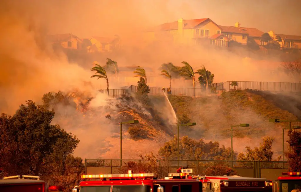
Los Angeles is extremely vulnerable to devastating wildfires due to hot, dry conditions, Santa Ana winds and proximity to wildland areas. Climate change is lengthening fire seasons and increasing fire frequency and intensity.
Major freeway systems crossing mountainous and canyon areas are chokepoints for fire evacuations. High-density neighborhoods adjacent to wildlands are at high risk of burning. The growing wildland-urban-interface puts over a million Angelenos in danger.
In November 2018, the Woolsey Fire in Ventura and L.A. counties killed 3 people and scorched 1,600 structures. The Station Fire north of L.A. in 2009 burned 160,000 acres. Fire seasons are starting earlier and lasting longer each year.
L.A. needs more controlled burning and fuel reduction in high-risk areas. Improved evacuation routes, emergency alerts and fire-resistant building materials will also help mitigate wildfire disasters. Homeowners must create defensible space and fire-wise landscaping around properties.
Major L.A. wildfires
- 1985 – Topanga Fire destroyed 75 homes
- 1993 – Old Topanga Fire destroyed 388 homes
- 2003 – Simi Fire burned 108,000 acres
- 2009 – Station Fire burned 160,000 acres
- 2018 – Woolsey Fire killed 3, burned 1,600 structures
Wildfire preparedness
Steps Angelenos can take to prepare for wildfire risks:
- Create defensible space around home – prune vegetation, clear brush
- Use fire-resistant landscaping and building materials
- Develop emergency evacuation plan and practice routes
- Ensure access to escape routes are clear
- Sign up for emergency alerts and monitor wildfire conditions
- Pack “go-bags” with essentials in case of evacuation order
Floods
While not as headline-grabbing as earthquakes or wildfires, flooding poses a highly underrated risk in Los Angeles. L.A. has a massive urbanized watershed covered in pavement and buildings that generates tremendous storm runoff. Flash floods and mudslides can occur, especially in wildfire-scarred areas stripped of vegetation.
El Niño winters with intense rainfall can overwhelm L.A.’s flood control system of channels, storm drains and dams. Homes from low-lying coastal areas to hillside properties are vulnerable. Mud and debris flows caused by heavy downpours have repeatedly flooded neighborhoods and triggered fatalities.
In 1938, a massive flood caused over $40 million in damage across L.A. County. Significant upgrades were made to the flood control system after that, but risks remain. In 2010, a storm dumped nearly 6 inches of rain, shutting down roads and transit. Experts warn future flood events could damage thousands of homes and businesses across L.A. Proper drainage maintenance and upgrades, stormwater capture projects and enhanced early warning systems are needed to prevent flood catastrophe.
Major L.A. flood events
- 1938 – Massive L.A. River flood, killed 87, submerged 300,000 acres
- 1969 – Century City mudslide killed 2, destroyed homes
- 1978 – Storm dropped record rainfall, deadly flooding
- 1980 – Storm dumped 10 inches on L.A., major flooding
- 2005 – Hillside debris flow killed 16 in La Conchita
Flood preparedness
Angelenos can take these steps to prepare for flood events:
- Know home’s flood risk – purchase flood insurance if needed
- Develop emergency plan for possible evacuation
- Prepare “go-bags” with supplies
- Sign up for emergency alerts about flooding
- Move valuables to upper floors or elevations
- Clear storm drains, gutters and drainage areas around home
Landslides
Steep slopes and unstable soils make landslides a serious localized threat across L.A.’s mountainous and coastal terrain. Ground that is saturated by heavy rainfall or shaken by earthquakes can give way, sending torrents of rock, soil and debris downhill damaging or demolishing anything in their path.
In recent years, extreme weather events triggered by climate change are causing more destructive landslides in L.A. Wildfires that denude hillsides of vegetation leave areas extremely prone to mudslides for years. This hazard played out with tragic results in 2018’s Montecito mudslides, which killed 23 people after fires.
L.A.’s Hollywood Hills, Topanga Canyon, Pacific Palisades and Santa Monica Mountains contain zones highly susceptible to slides. Improving slope stability, draining surface water and early warning systems are critical to reducing risks. Residents in landslide zones should educate themselves and prepare emergency plans.
Major L.A. landslides
- 1956 – Chimney Rock landslide in Pacific Palisades destroyed 13 homes
- 1978 – Bluebird Canyon landslide in Laguna Beach killed 23
- 2005 – La Conchita landslide killed 10 in Ventura County
- 2018 – Montecito mudslides killed 23 after Thomas Fire
Landslide preparedness
Preparedness steps for residents in landslide zones:
- Monitor rain forecasts and heed evacuation orders
- Stabilize slopes around home with vegetation, retaining walls
- Watch for warning signs like small slides, tilted trees, cracking soil
- Develop emergency response plan with escape routes
- Purchase mudslide insurance if area is prone to flows
Tsunamis
Coastal communities in Los Angeles face low-frequency, high-impact risks from tsunamis – giant waves triggered by earthquakes, landslides or volcanic eruptions over the ocean. While rare, tsunamis have the potential to inflict calamitous damage. A large offshore quake could send a 15 to 20-foot wave crashing into L.A. beaches within minutes, flooding inland areas.
Low-lying locations like Marina Del Rey and parts of Long Beach and Venice are especially vulnerable. The ports of Los Angeles and Long Beach – some of the busiest in the world – would be severely impacted by tsunami damage.
An early warning system is in place to detect far-off tsunamis and alert coastal residents to evacuate. Clearly marked escape routes have been designated, guiding people to higher elevations and safety. Continued efforts are needed to improve tsunami readiness, such as designating reinforced vertical evacuation structures.
Historical tsunamis
Notable tsunamis impacting L.A. region:
- 1812 – Santa Barbara tsunami from offshore quake killed 3
- 1908 – 6-foot waves hit Port Los Angeles after Aleutian Islands quake
- 1933 – Long Beach tsunami killed 120 from offshore quake
- 1946 – 7-foot waves struck shore after Aleutian Islands quake
- 1960 – 6-foot tsunami hit L.A. after Chile earthquake
Tsunami preparedness
How coastal L.A. residents can prepare:
- Know tsunami risk zones and designated evacuation routes
- Practice evacuating quickly to high ground or inland
- Heed natural warnings like ground shaking or rapid water drawback
- Sign up for emergency alerts and tsunami warnings
- Keep emergency kits with supplies in easy-to-grab locations
Severe Weather Events
Los Angeles faces growing risks from extreme weather events fueled by climate change. Rising temperatures contribute to drought, which leaves vegetation tinder-dry and drives larger wildfires. Heat waves now grip Southern California, causing heat stroke and breathing difficulties, especially in vulnerable populations.
L.A. frequently contends with dangerous Santa Ana wind conditions. These hot, extremely dry downslope winds fan wildfire spread. Climate studies predict Santa Anas will increase in frequency and severity.
While less common than in other regions, severe storms can still strike L.A. El Niño winters can bring intense downpours leading to flooding and mudslides. Freak hail, lightning or even tornado strikes are also possible with the right conditions. Public warning systems, emergency planning and infrastructure upgrades to handle extreme weather are key to improving L.A.’s resilience.
Geological Threats
Beyond earthquakes, L.A. faces other serious geological hazards. The great sedimentary deposits underlying the city make the ground prone to liquefaction during prolonged shaking. Saturated sandy soils mix with groundwater, temporarily transforming into a fluid mass unable to support structures. Liquefaction caused extreme damage in the 1964 Alaska quake.
Parts of L.A., particularly the San Fernando Valley, were once wetlands and retain high groundwater levels. The weight of large buildings here can cause the ground to subside. Both liquefaction and subsidence risks highlight the importance of effective seismic building standards.
Conclusion
While no major city can be fully disaster-proof, Los Angeles has made strides in emergency preparedness and infrastructure. Continued vigilance and investment is required to mitigate the worst outcomes from inevitable natural hazards. Education, early warning systems, drills, emergency kits and response plans empower the public to stay safe when disaster strikes. However, more action is needed to address vulnerabilities and make L.A. one of the world’s most resilient metropolises.