Hurricane Sandy was one of the most destructive hurricanes to hit the United States in recent history. Making landfall in late October 2012, the massive storm swept through the Caribbean and up the East Coast, causing widespread damage and flooding in New York and New Jersey in particular. Sandy revealed flaws in storm preparedness and disaster response at all levels of government. The storm provided valuable lessons on how to better prepare for and respond to future extreme weather events.
What made Hurricane Sandy so destructive?
Hurricane Sandy earned the infamous nickname “Superstorm Sandy” due to its immense size and destructive impacts. Sandy was an unusually large hurricane, spanning over 1,000 miles wide at times. It merged with a developing nor’easter storm system prior to landfall, which amplified its size and intensity. This merger also caused the storm to hook sharply westward and slam into the New Jersey coast rather than continue northeast and spare coastal areas. Sandy made landfall as a post-tropical cyclone, meaning it transitioned from a hurricane to an extratropical storm just before coming ashore. However, Sandy still packed hurricane-force winds up to 80 mph. The wind field was massive, with hurricane and tropical storm-force winds extending hundreds of miles wide. This subjected much of the Mid-Atlantic to prolonged hours of intense winds.
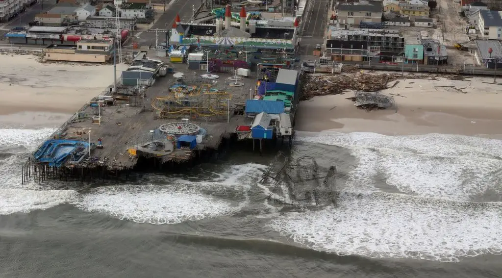
In addition, Sandy drove a catastrophic storm surge into coastal areas. New York Harbor experienced a 14 foot storm surge, flooding parts of Lower Manhattan. A record storm surge of 13.88 feet occurred at the Battery in Southern Manhattan. Sandy’s enormous size allowed it to persist for days and pile water up into a huge, destructive storm surge. The full moon during Sandy’s approach also worsened its effects.
The storm’s arrival coincided with high tide along the East Coast. The combination of storm surge and high tide produced extreme inundation levels. Many areas were inundated with flood waters that did not recede for days. The powerful waves and surge scoured and eroded dunes and shorelines. They smashed boardwalks, sea walls, fishing piers and other coastal infrastructure. Flooding was most severe in New York City, Atlantic City and the Jersey Shore region. However, Sandy also caused moderate to major coastal flooding well northward into New England.
Inland, Sandy dumped heavy rainfall of 6 to 12 inches in many areas. The ground was already saturated from previous wet weather. The excessive rainfall caused widespread flooding, overflowing rivers, lakes and dams. Mountainous areas saw more than two feet of heavy, wet snowfall. Blizzard conditions occurred at higher elevations in states like West Virginia, Virginia and Tennessee. The winds and heavy precipitation downed countless trees and power lines across more than a dozen states.
The immense size, power and multifaceted impacts make Hurricane Sandy one of the most destructive and costliest storms on record in the U.S. The death toll from Sandy stands at 233 people. The storm caused about $70 billion in damage, second only to Hurricane Katrina. Over 650,000 homes were damaged or destroyed and over 8.5 million customers lost power during Sandy. The effects were felt hundreds of miles inland as well as throughout the Caribbean.
Failures in Emergency Preparedness and Response
Hurricane Sandy exposed serious deficiencies in emergency preparedness and disaster response capabilities. At the city and state level, the storm revealed poor planning for catastrophic flooding events. New York City’s response during Sandy was hampered by lack of experienced leadership. The head of New York’s Office of Emergency Management had just taken over the role in September 2012, one month before Sandy struck. He lacked familiarity with the elaborate coastal storm plans in place. As a result, the city failed to issue timely evacuation orders or stockpile enough supplies like food, water and generators in preparation for power outages.
New York and New Jersey enacted fuel supply contingency plans as Sandy approached. However, breakdowns in communications, trapped freight trucks and flooded infrastructure prevented effective fuel distribution. Many gas stations could not pump gas to serve evacuation traffic or emergency vehicles. Lack of fuel for generators contributed to prolonged power outages at gas stations, grocery stores and healthcare facilities.
At hospitals that remained open during the hurricane, backup generator failures caused dangerous patient evacuations. New York University’s Langone Medical Center had to evacuate over 200 patients, including critically ill newborns from its neonatal intensive care unit. Lacking power, staff were forced to manually pump air into the lungs of infants and carry them down multiple flights of stairs to evacuate them.
Poor intergovernmental coordination also hindered the response. FEMA experienced difficulties mobilizing supplies like food, water and generators into affected regions. FEMA and the Red Cross underestimated the locations and number of evacuees needing shelters. Just days before Sandy made landfall, FEMA removed many emergency supplies and assets from the New York/New Jersey area to prepare for a different storm threat. As a result, FEMA staging areas lacked 40% of requested resources for power restoration and feeding operations. States and power companies competed over limited disaster response resources.
Steps to Improve Storm Preparedness and Response
In Sandy’s aftermath, agencies at all levels of government re-evaluated policies and took steps to bolster storm preparedness and streamline disaster response:
– New York City restructured its Office of Emergency Management, requiring the director have deep experience handling disasters. Annual disaster drills now prepare the city for different catastrophic scenarios like hurricanes, coastal flooding and infrastructure failures. Flood-prone areas of the city have stockpiles of emergency supplies like food and water.
– Hospitals reinforced generators, relocated electrical equipment to higher floors and created contingency plans to ensure backup power continuity. NYU Langone invested over $1 billion to protect against 500-year flood levels.
– FEMA revised its logistics and resource allocation processes to get supplies deployed faster before storms make landfall. It now pre-stages more assets inland to avoid last-minute scrambles if forecasts shift. Communications and resource tracking were enhanced to coordinate needs between states more efficiently.
– States adopted mutual aid compacts so they can share response resources quickly during crises. Regional staging areas make food, water and generators more accessible.
– The NY-NJ Port Authority invested billions to make facilities and infrastructure more resilient. Flood walls, raised entrances and waterproofing projects better protect tunnels, airports, bridges and commuter rail systems from surge.
– Building codes were toughened in New York and New Jersey to require more flood-resistant designs. Homes in high-risk areas must be elevated on piles or pilings. Critical systems like utilities and life safety equipment must be floodproofed or elevated above expected flood levels.
Effect on Coastal Flood Mapping
Hurricane Sandy exposed inaccuracies in FEMA’s flood maps used to guide coastal planning and determine flood insurance rates. Many of the areas inundated by Sandy’s floodwaters were outside high-risk zones on FEMA’s Flood Insurance Rate Maps (FIRMs). On some maps, zones had not been updated in over 25 years despite better understanding of flood risks. Outdated maps gave communities a false sense of security.
Sandy flooded areas home to twice as many people than were in the mapped high-risk flood zones. Over 70% of the damage occurred to structures in zones shown as moderate-to-low risk. In New Jersey alone, over $2.7 billion in Sandy damage hit areas considered low or minimal flood risk on outdated FIRMs.
Clearly, existing maps failed to capture current coastal risks. Sandy’s impacts underscored the need to redraw FIRMs using higher resolution mapping techniques and the latest data on flood hazards.
In response, FEMA put new mapping procedures into place:
– Advanced laser imaging and elevation data is collected to create highly accurate, digital FIRMs. Maps issued today are far more precise than hand-drawn paper maps used previously.
– Coastal maps incorporate new storm surge modeling and take sea level rise into account. They utilize the latest hurricane models and damage data from storms like Sandy.
– Maps are assessed regularly and updated every 5 years for coastal areas to keep pace with changing conditions versus once every 10-15 years previously.
Updated FIRMs provide citizens and communities a much clearer picture of their true flood vulnerabilities. This allows them to make smarter decisions about building resilience, mitigating risks and carrying adequate flood insurance.
Boosting Community Resilience
Beyond the disaster response failures, Hurricane Sandy also revealed how ill-prepared many communities were for a powerful storm. In New York and New Jersey, many homes and infrastructure lacked basic protections against flood and wind damage.
In response, both states launched new resilience initiatives and programs:
– New York’s NY Rising Community Reconstruction Program funded over $650 million toward recovery and resiliency projects. States provided grants and technical support for communities to rebuild damaged infrastructure and homes to be more resilient.
– New Jersey passed uniform statewide floodplain development standards. All buildings in flood zones must now meet minimum elevation requirements. Many repetitive loss properties have been acquired and demolished or elevated on piles.
– Towns evaluated critical facilities like police, fire, hospitals and utilities to floodproof or relocate them from high-risk areas. Many installed larger backup generators and reinforced buildings against hurricane winds.
– Natural infrastructure projects like dune restoration, marsh creation and oyster reefs now buffer waterfront areas. They dissipate waves and trap sediment to prevent beach and shoreline erosion during storms.
– Residents elevated homes, installed flood vents and used flood-resistant materials during repairs to reduce damage from future storms.
Changes to Coastal Flood Risk Policies
Hurricane Sandy revealed that existing coastal flood risk policies were not keeping pace with increasing vulnerabilities from development and climate change. In response, reforms were made at the federal and local levels:
– FEMA overhauled the National Flood Insurance Program (NFIP) to stabilize its finances and better communicate coastal risks through flood maps and insurance rates. Premiums increased across the board to reflect true risk levels. Discounted rates were phased out.
– Payouts from the NFIP now account for the full replacement cost to rebuild a severely damaged home. This provides more incentive for property owners to proactively mitigate risks versus receiving discounted insurance rates while still getting full rebuild coverage.
– New floodplain development standards prohibit certain high-risk construction. Critical facilities like hospitals cannot be built in 100-year floodplains.
– Some states expanded coastal construction setbacks to account for rising seas and larger storms. Dune systems, wetlands and beaches are preserved as natural buffers.
– Buyout programs turn vulnerable properties into open space. Repeatedly flooded areas can no longer be redeveloped.
– New York and New Jersey are developing incentives for transfer of development rights. Rights can be sold to build at higher densities inland, steering development away from hazardous coastal zones.
Investing in Climate Resilience
Hurricane Sandy served as a wake-up call on the vulnerabilities coastal cities face from climate change. Sea levels in the New York region rose over 1 foot during the 20th century. Adding storm surge on top puts more areas at risk of catastrophic flooding. Global warming is expected to accelerate seal level rise and may increase hurricane intensity and rainfall rates.
Major metropolitan areas recognized they must take decisive action to adapt. After Sandy, New York City formulated a $20 billion climate resiliency plan to gird against future impacts. It focuses on flood protection, upgrading buildings, protecting infrastructure and making neighborhoods more resilient. Specific initiatives include:
– Massive flood barriers and levee systems will be constructed to seal off vulnerable areas. Deployable floodwalls can be erected prior to storms.
– Older buildings will be required to waterproof equipment, upgrade boilers and ensure critical systems are protected from saltwater corrosion. Financial incentives encourage proactive upgrades.
– Parks, sidewalks and pavement will better absorb floodwaters through porous surfaces and bioswales. Rain gardens and green streets retain stormwater.
– Hospitals implement microgrid systems to generate and store onsite renewable energy. Healthcare operations can continue uninterrupted during prolonged power outages.
– Redundant telecommunications networks are installed. Flood-prone tunnels, subways and rail lines are sealed against water intrusion.
– Backup food distribution and health asset networks bolster community resilience in high risk neighborhoods.
– Wetland restoration and floodplain reconnection reduce coastal erosion while improving natural buffers against storm surge.
Major commitments like these exemplify how cities like New York aim to be far better positioned to handle the next Hurricane Sandy.
Conclusion
Hurricane Sandy spotlighted glaring weaknesses in the nation’s disaster preparedness and response capabilities. However, the storm also led to major changes that will reduce impacts from future storms. At all levels, Sandy prompted evaluations of what went wrong and where improvements were needed. Policy reforms, infrastructure upgrades and a shift in mindset toward proactive resilience have emerged in Sandy’s aftermath. While disasters will continue to challenge coastal communities, the lessons learned from Sandy have better positioned the region to plan for, absorb and recover from future storms.
